


Introduction
Aerial photography has revolutionized the way we experience and understand some of the most awe-inspiring natural wonders of our planet. By capturing stunning landscapes from above, drone technology has opened up new possibilities for photographers, filmmakers, and nature enthusiasts alike. Among the most captivating subjects for aerial photography are volcanoes, canyons, and giant glaciers—each of which offers a unique combination of dramatic geological formations and natural beauty.
These landscapes, often harsh and inhospitable, are transformed when viewed from the sky. From the fiery craters of active volcanoes to the deep and winding labyrinths of canyons, and the vast, ice-covered expanses of glaciers, aerial shots can bring out the immensity, complexity, and raw beauty of these natural wonders. In this article, we will explore the significance of these geological features, delve into the techniques used to photograph them from the sky, and discuss some of the most remarkable examples of volcano, canyon, and glacier landscapes captured through aerial photography.
1. Understanding the Geological Wonders: Volcanoes, Canyons, and Glaciers
Before diving into the specifics of aerial photography, it’s important to appreciate the geological significance of the features we are capturing. Each of these natural wonders has its own unique characteristics, shaped by millions of years of geological activity.
1.1 Volcanoes: The Fiery Heart of the Earth
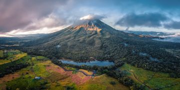
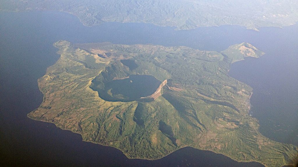
Volcanoes are some of the most dynamic and powerful natural formations on Earth. They are created when magma from beneath the Earth’s crust erupts to the surface, forming mountains and craters. Volcanoes can vary greatly in shape and size, from shield volcanoes, which are broad and gently sloping, to stratovolcanoes, which are steeper and more explosive.
- Active Volcanoes: Some volcanoes remain active, continuously emitting smoke, ash, and lava. These volcanoes present both a natural spectacle and a significant danger to nearby populations.
- Dormant Volcanoes: These are volcanoes that have not erupted in recent history but may still erupt again in the future. They are often characterized by their large calderas (crater-like depressions).
- Extinct Volcanoes: These volcanoes have not erupted for thousands of years and are considered to be inactive.
From an aerial perspective, volcanoes offer an incredible opportunity to capture not only their massive size but also their crater formations, lava flows, and the surrounding landscapes affected by volcanic activity.
1.2 Canyons: Earth’s Grand Carvings
Canyons are deep, narrow valleys with steep sides, typically formed by erosion from rivers, glaciers, or tectonic activity. These geological formations offer stunning contrasts between light and shadow, as well as unique opportunities to capture their winding paths from above.
- Formation: Canyons are typically formed over millions of years by the erosive power of water. Rivers carve through rock layers, cutting deep into the Earth’s surface and creating the iconic U-shaped valleys we recognize today.
- Famous Canyons: The Grand Canyon in the U.S., the Fish River Canyon in Namibia, and the Colca Canyon in Peru are among the most famous. These natural wonders provide an almost alien-like landscape, where vast expanses of rock and earth are split by deep, serpentine gorges.
Aerial views of canyons allow photographers to show the full scale of these immense chasms, revealing the complexity of their rock layers, rugged terrain, and river systems in a way that ground-based photography cannot.
1.3 Glaciers: Giants of Ice
Glaciers are vast, slow-moving rivers of ice that form in cold regions where the accumulation of snow exceeds its melting rate. These massive ice sheets can stretch for miles, carving valleys, fjords, and other striking landforms along the way. As a result, glaciers are a photographer’s dream, offering sweeping panoramas of ice and snow in ever-changing shapes.
- Formation: Glaciers form when snow compacts over time, becoming thick layers of ice. Under the pressure of their own weight, glaciers slowly move downhill, carving the landscape below.
- Global Distribution: Glaciers are found on every continent, with significant ice sheets covering regions like Antarctica, Greenland, and the high mountains of the Himalayas, Alps, and Andes.
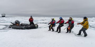
Aerial photographs of glaciers can capture their vastness, their blue ice, and their glacial tongues that stretch into valleys, offering a perspective that emphasizes the scale of these frozen rivers of ice.
2. The Techniques of Aerial Photography
Capturing volcanoes, canyons, and glaciers from the air requires a distinct set of techniques and tools. Aerial photography offers a perspective that reveals the vastness and intricate details of these natural wonders, but it also presents unique challenges. Here’s a breakdown of the techniques used in photographing these geological features from the sky.
2.1 Drones: The New Frontier in Aerial Photography
In the past, aerial photography was the realm of helicopters and airplanes. However, with the rise of drone technology, photographers now have unprecedented access to remote locations, enabling them to capture shots that were once only possible from a plane.
- Drone Types: The most common drones for landscape photography are quadcopters, which are stable, easy to control, and able to carry high-quality cameras. Popular models include the DJI Phantom, DJI Mavic, and Autel Robotics EVO.
- Camera Settings: To capture the sharpest and most detailed images, drone photographers typically use high-resolution cameras with settings adjusted for the right exposure, ISO, and shutter speed. For wide vistas, a wide-angle lens is often preferred.
- Flight Time and Battery Life: One of the main limitations of drones is their flight time, which typically ranges between 20 to 30 minutes. This means careful planning and understanding of flight paths are essential for maximizing each flight.
2.2 Aerial Composition and Framing
Framing a shot from the sky requires careful consideration of several factors:
- Leading Lines: Canyons and glaciers often feature natural leading lines—such as rivers, valleys, and crevasses—that can be used to guide the viewer’s eye through the image.
- Golden Hour: Like traditional photography, the golden hour (just after sunrise or before sunset) is ideal for capturing soft, warm light that enhances the textures and contours of volcanoes, canyons, and glaciers.
- Perspective and Scale: Aerial shots can be taken from various altitudes and angles to emphasize the scale of the landscape. Shooting from a higher altitude can reveal the immensity of a canyon or glacier, while a closer shot may focus on the intricate details of volcanic craters or ice formations.
2.3 Post-Processing and Enhancement
After capturing the raw images, post-processing plays a vital role in enhancing the photograph. For aerial shots of geological features, photographers often:
- Enhance Contrast: Aerial landscapes can benefit from boosted contrast, which highlights the natural textures of rocks, ice, and earth.
- Increase Clarity: Sharpening and enhancing the clarity of fine details, such as the surface of glaciers or the folds of canyon walls, can provide a sense of depth and texture.
- Adjust Colors: Some photographers enhance the colors of the landscape to make volcanic lava flows appear more dramatic or to emphasize the deep blues of glaciers.
3. Notable Locations for Aerial Photography of Volcanoes, Canyons, and Glaciers
The world is home to numerous volcanoes, canyons, and glaciers that offer extraordinary aerial photography opportunities. Here are a few of the most iconic locations where photographers have captured breathtaking views from the sky.
3.1 Volcanoes
- Mount Vesuvius (Italy): This active volcano is known for its catastrophic eruption in AD 79, which destroyed the Roman cities of Pompeii and Herculaneum. Aerial photography of its caldera and surrounding areas captures the ongoing volcanic activity.
- Mount St. Helens (USA): Famous for its 1980 eruption, this volcano has been heavily studied for its effects on the environment. Aerial shots often focus on the devastated landscape around the volcano and the regrowth of surrounding vegetation.
- Kīlauea (Hawaii): One of the most active volcanoes in the world, Kīlauea offers aerial views of lava flows cascading into the ocean, providing photographers with a unique and dynamic landscape.
3.2 Canyons
- Grand Canyon (USA): This iconic canyon, carved by the Colorado River, is perhaps the most famous example of canyon photography. Aerial shots reveal the vastness of the canyon’s layers of rock, deep ravines, and meandering river.
- Fish River Canyon (Namibia): The largest canyon in Africa, Fish River Canyon offers dramatic, desolate landscapes with stark contrasts between light and shadow.
- Colca Canyon (Peru): Known for being deeper than the Grand Canyon, Colca Canyon is famous for its terracing, deep ravines, and the Andean condor soaring above.
3.3 Glaciers
- Vatnajökull Glacier (Iceland): The largest glacier in Europe, Vatnajökull features vast ice caps, deep crevasses, and glacial rivers that create striking aerial compositions.
- Perito Moreno Glacier (Argentina): This advancing glacier in Patagonia is famous for its ice walls, which regularly calve massive chunks of ice into the surrounding lake.
- Antarctica: The remote glaciers of Antarctica offer some of the most breathtaking aerial views on Earth. Vast ice shelves and towering icebergs dominate the landscape, creating scenes of unearthly beauty.
4. Conclusion: The Future of Aerial Landscape Photography
The advent of drone technology has opened up new frontiers in landscape photography, allowing us to explore and capture the magnificent scale of natural wonders like volcanoes, canyons, and glaciers from a unique perspective. With advancements in drone technology, improved camera quality, and better flight times, the possibilities for capturing these geological wonders will continue to expand.
As aerial photographers, we now have the ability to create timeless images that not only showcase the power and beauty of nature but also serve as a reminder of the importance of preserving these remarkable landscapes. Whether photographing the smoldering lava of an active volcano, the deep, jagged ridges of a canyon, or the icy expanse of a glacier, aerial photography enables us to appreciate these natural wonders in ways that were previously unimaginable.


