


Spanning over 3,100 miles from Canada to Mexico, the Continental Divide Trail (CDT) is one of the most iconic and challenging long-distance hiking routes in the United States. This trail, which follows the crest of the Rocky Mountains, offers hikers an unparalleled adventure, traversing through diverse landscapes, remote wilderness areas, and some of the most rugged terrain in North America. The CDT is a true test of endurance, requiring hikers to not only navigate vast distances but also adapt to constantly changing environmental conditions, from high-altitude snowfields to scorching desert landscapes.
Unlike its more famous counterparts, the Pacific Crest Trail (PCT) and Appalachian Trail (AT), the CDT remains less crowded and offers a more solitary experience, attracting those who seek a raw, unfiltered wilderness experience. However, with its vastness comes a host of challenges: from unpredictable weather and isolation to the physical demands of hiking across steep mountain ridges and desert valleys. In this article, we will explore the Continental Divide Trail in detail—its history, its route, its challenges, and the rewards that await those who choose to embark on this remarkable journey.
1. Introduction: The Allure of the Continental Divide Trail
The Continental Divide Trail is a long-distance hiking route that follows the Continental Divide, the geographical line that separates the watersheds of the Atlantic and Pacific Oceans. The trail passes through five U.S. states: Montana, Wyoming, Colorado, New Mexico, and finally, it stretches down to the U.S.-Mexico border in New Mexico. The CDT is the third of the United States’ Triple Crown of hiking (the PCT and AT are the other two), and is often considered the most difficult of the three, both due to its terrain and the remoteness of its sections.
While the CDT was officially designated as a National Scenic Trail in 1978, it wasn’t until 2000 that it was fully mapped, and until recently, its construction was incomplete in some sections. As a result, the trail is still a work in progress, and many hikers venture into unmarked or lightly maintained areas, making it a more rugged and exploratory experience than other major hiking routes.
1.1 A Connection to the Land
For many who take on the CDT, the hike is not just about the physical challenge but also about the deep connection to nature and the landscape. The trail is a testament to the rugged beauty of North America, offering hikers the opportunity to witness breathtaking panoramas of high mountain ranges, expansive meadows, pristine lakes, and remote desert landscapes. It is a place where the immense scale of nature becomes palpable, and where the solitude of the wilderness fosters introspection and personal growth.
2. The Continental Divide: The Geography Behind the Trail
The Continental Divide, also known as the Great Divide, is a natural boundary that runs from the northernmost parts of North America in Canada, through the United States, and all the way to Mexico. This divide separates the water flow that drains into the Pacific Ocean from the water that drains into the Atlantic Ocean. The divide is marked by high mountain ridges and plateaus, which create the perfect path for the Continental Divide Trail.
2.1 Understanding the Landscape
The CDT follows the spine of the Continental Divide, which consists of steep mountain ridges, high deserts, and lush valleys. Along its path, hikers encounter a variety of ecosystems, each with its own distinct flora and fauna. From the alpine meadows of the Rockies to the arid, sun-scorched deserts of New Mexico, the landscape along the CDT is a microcosm of North America’s natural diversity.
In addition to the natural beauty, the divide itself is a significant geographical feature, often appearing as a series of jagged ridges or long, sweeping plateaus. The trail follows these ridges, often with dramatic drop-offs on either side, providing hikers with a sense of remoteness and elevation that few other trails offer.
2.2 Unique Ecological Zones
- Alpine Zones: In states like Montana and Wyoming, the trail takes hikers through high alpine terrain, where snow can linger well into the summer months. These areas are characterized by wildflower meadows, pristine glacial lakes, and towering peaks.
- Subalpine Forests: As hikers descend in elevation, the landscape transitions into subalpine forests, which feature dense groves of pine, spruce, and fir trees. These forests are home to a variety of wildlife, including elk, mule deer, and black bears.
- Desert Landscapes: As the trail moves into New Mexico and southern Colorado, the landscape shifts dramatically to arid deserts and canyons. Hikers must navigate through dry, dusty environments, encountering desert flora like cactus and yucca, along with the occasional sighting of desert wildlife such as lizards, rattlesnakes, and coyotes.
3. The Route of the CDT: States, Highlights, and Challenges
The Continental Divide Trail stretches across five states: Montana, Wyoming, Colorado, New Mexico, and finally ends at the U.S.-Mexico border in New Mexico. Each state presents its own set of challenges and unique features, and each section of the CDT offers hikers something different. Let’s explore the route in greater detail.
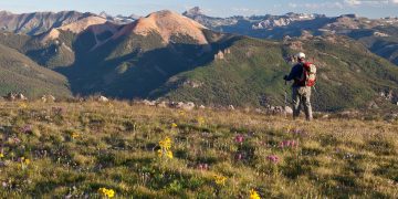
3.1 Montana: Majestic Wilderness and the Start of the Journey
The CDT begins in the northern Rocky Mountains of Montana, near the Canadian border. The first section is rugged and remote, with hikers navigating through dense forests, high alpine meadows, and along glacial rivers. The Flathead Range and the Bob Marshall Wilderness are two major highlights of this section. These areas are known for their pristine beauty and high biodiversity, and they provide some of the toughest challenges for hikers, with steep climbs and unpredictable weather.
Montana’s vast wilderness stretches for hundreds of miles, and it can be easy to feel small in such an expansive landscape. This section is also known for its wildlife—grizzly bears, wolves, and mountain lions roam these forests, and hikers must remain vigilant as they move through bear country.
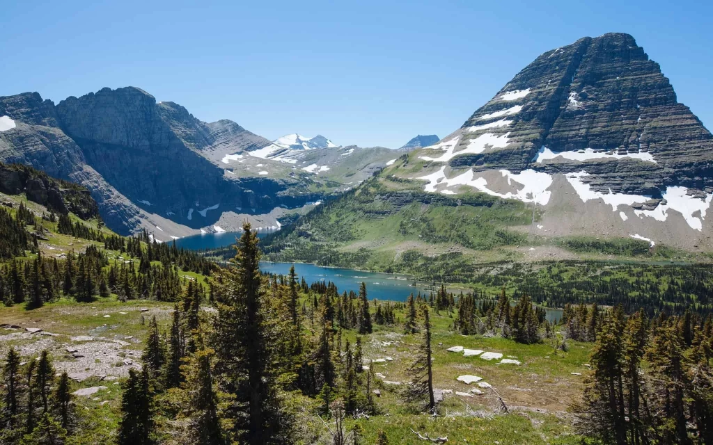
3.2 Wyoming: Rocky Mountains and Alpine Lakes
Next, hikers make their way south into Wyoming, home to the Teton Range and Wind River Range. Wyoming’s section of the CDT features some of the most spectacular alpine landscapes on the entire trail, with crystal-clear lakes, rugged peaks, and sprawling meadows. The trail passes through areas like the Bridger-Teton National Forest and the Yellowstone region, providing hikers with expansive views and challenging climbs.
The Wind River Range, in particular, is known for its dramatic terrain, with high mountain passes, alpine lakes, and a sense of remoteness that few other places in the U.S. can replicate. This section also contains some of the most physically demanding sections of the CDT, where hikers must climb and descend steep slopes and contend with potential snowfields well into the summer months.
3.3 Colorado: The High Point of the Continental Divide
Colorado is home to the highest section of the Continental Divide Trail, and it presents some of the most challenging and rewarding hiking experiences along the route. The trail crosses over numerous 14,000-foot peaks, including Mount Elbert, the highest peak in Colorado. These high-altitude climbs require hikers to be in peak physical condition, as the thin air at such elevations can be exhausting and difficult to adapt to.
The trail also passes through the San Juan Mountains, an area known for its stunning beauty, remote high-altitude lakes, and challenging terrain. While Colorado offers some of the most rewarding views and alpine landscapes on the CDT, it also presents serious weather challenges, including frequent thunderstorms and sudden drops in temperature.
3.4 New Mexico: The Desert and the Final Stretch
New Mexico marks the final stretch of the Continental Divide Trail before it reaches the U.S.-Mexico border. The landscape here is a stark contrast to the alpine beauty of Montana and Colorado. The trail moves through dry deserts, rocky canyons, and wide, sun-scorched plains. One of the most notable challenges of this section is the heat, which can be unbearable in the summer months. Hikers must be prepared for long stretches with limited water sources and extreme temperatures.
Despite the harsh environment, New Mexico offers its own unique beauty. The Gila Wilderness, one of the highlights of this section, is an isolated and stunning region of high deserts, rugged mountains, and deep canyons. The CDT’s final stretch before reaching the Mexican border is marked by a sense of accomplishment as hikers complete the longest and most challenging of America’s National Scenic Trails.
4. The Challenges of Hiking the CDT
While the CDT offers incredible beauty and adventure, it also comes with a unique set of challenges. These challenges make the trail more difficult than other well-known long-distance hikes, such as the Appalachian Trail and Pacific Crest Trail.
4.1 The Length and Remoteness
At over 3,100 miles, the CDT is a massive undertaking, requiring months of hiking to complete. It’s not a trail for the faint of heart, and hikers must be mentally prepared for long stretches of isolation, harsh terrain, and unpredictable weather. The trail is often very remote, with limited access points and few resupply stations. This makes preparation and self-sufficiency essential.
4.2 Weather Conditions
Weather on the CDT is notoriously unpredictable. Hikers can experience scorching heat in the desert, blizzards in the mountains, and sudden thunderstorms at high altitudes. The terrain can range from snowy, icy passes to dry, dusty stretches of desert. Navigating these conditions requires both physical endurance and the ability to adapt to changing weather patterns.
4.3 Navigation and Trail Maintenance
While the CDT is a designated National Scenic Trail, much of it remains undeveloped and less maintained than other major trails. Hikers must be prepared to navigate without relying on marked signs or clear trailheads. In some sections, the trail is poorly marked, and hikers may need to use maps and GPS to stay on course.
5. Preparation and Tips for Hiking the CDT
Successfully completing the Continental Divide Trail requires careful planning, preparation, and training. Here are some essential tips for those considering hiking the CDT:
- Physical Preparation: The CDT is physically demanding, so hikers should be in top physical condition before starting the trail. Training should include endurance hikes, climbing, and carrying heavy loads to prepare for the tough terrain.
- Gear and Supplies: Proper gear is crucial for the CDT. Hikers need lightweight, durable equipment that can withstand extreme conditions. A high-quality backpack, lightweight tent, sleeping bag for cold weather, and reliable footwear are all essential.
- Resupply Planning: Because the CDT is long and remote, planning resupplies is key. Hikers should know where to find food and water along the trail and plan their trips accordingly.
6. Conclusion: The Reward of Conquering the Continental Divide
Hiking the Continental Divide Trail is one of the most rewarding and challenging experiences in the world of long-distance hiking. With its stunning landscapes, extreme weather conditions, and remoteness, the CDT offers an unparalleled adventure for those brave enough to take it on. Completing the trail is not just about conquering mountains—it’s about testing your limits, connecting with nature, and discovering the true spirit of adventure. Whether you’re looking to challenge yourself physically or simply seek an unforgettable wilderness experience, the Continental Divide Trail is a journey worth embarking on.


